


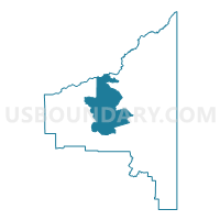
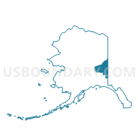
Dot Lake Precinct, Southeast Fairbanks Census Area, Alaska
About
Outline

Summary
| Unique Area Identifier | 523521 |
| Name | Dot Lake Precinct |
| County | Southeast Fairbanks Census Area |
| State | Alaska |
| Area (square miles) | 2,758.25 |
| Land Area (square miles) | 2,734.23 |
| Water Area (square miles) | 24.02 |
| % of Land Area | 99.13 |
| % of Water Area | 0.87 |
| Latitude of the Internal Point | 63.96087670 |
| Longtitude of the Internal Point | -144.14873830 |
Maps

Graphs
Select a template below for downloading or customizing gragh for Dot Lake Precinct, Southeast Fairbanks Census Area, Alaska


Neighbors
Neighoring Voting District (by Name) Neighboring Voting District on the Map
- Big Delta Precinct, Southeast Fairbanks Census Area, AK
- Deltana Precinct, Southeast Fairbanks Census Area, AK
- Eagle Precinct (Part; Also See Part In Yukon-Koyukuk Census Area), Southeast Fairbanks Census Area, AK
- Mentasta Precinct (Part; Also See Part In Valdez Cordova Census Area), Southeast Fairbanks Census Area, AK
- Salcha Precinct, Fairbanks North Star Borough, AK
- Tanacross Precinct, Southeast Fairbanks Census Area, AK
Top 10 Neighboring County Subdivision (by Population) Neighboring County Subdivision on the Map
- Fairbanks North Star census subarea, Fairbanks North Star Borough, AK (97,581)
- Southeast Fairbanks census subarea, Southeast Fairbanks Census Area, AK (7,029)
Top 10 Neighboring Place (by Population) Neighboring Place on the Map
- Deltana CDP, AK (2,251)
- Dry Creek CDP, AK (94)
- Dot Lake Village CDP, AK (62)
- Healy Lake CDP, AK (13)
- Dot Lake CDP, AK (13)
Top 10 Neighboring Unified School District (by Population) Neighboring Unified School District on the Map
- Fairbanks North Star Borough School District, AK (97,581)
- Delta/Greely School District, AK (4,810)
- Alaska Gateway School District, AK (2,344)
Top 10 Neighboring State Legislative District Lower Chamber (by Population) Neighboring State Legislative District Lower Chamber on the Map
- State House District 12, Richardson-Glenn Highways, AK (14,811)
- State House District 6, Interior Villages, AK (14,235)
Top 10 Neighboring State Legislative District Upper Chamber (by Population) Neighboring State Legislative District Upper Chamber on the Map
Top 10 Neighboring 111th Congressional District (by Population) Neighboring 111th Congressional District on the Map
Top 10 Neighboring Census Tract (by Population) Neighboring Census Tract on the Map
- Census Tract 4, Southeast Fairbanks Census Area, AK (4,810)
- Census Tract 1, Southeast Fairbanks Census Area, AK (2,219)
- Census Tract 17, Fairbanks North Star Borough, AK (1,422)